SEDIMENTS

TILLS & PEAT
The ice sheets and glaciers deposited large amounts of sediment eroded from higher ground. This type of sediment is called till and is a mixture of sand and gravel with larger stones (also known as clasts). Clast orientation permits reconstruction of the ice flow. The till has, in large parts, “plugged” holes in the limestone, allowing for lakes and rivers to form. The till is also the base on which organic soils accumulated and where trees, grass and crops grew. Agriculture arrived in the Neolithic, with the first farmers settling in Ireland about 6000 years ago and cultivating crops for food. The clasts in the till are a major feature of the landscape in our geopark area; when farmers started to plough their fields, they needed to remove many of these stones and used them to build the drystone walls that surround their fields.


Our Irish climate is characterised by high rainfall and small seasonal variations in temperature (very few days are either below 0°C or above 30°C). The position of the Irish landmass, as an outpost on the edge of the North Atlantic Ocean, is the reason for this and the fact that there has been limited changes in the Irish climate since the end of the last Ice Age. There is evidence for peat, an accumulation of partially decayed plants, to have grown in Ireland for 9,000 years and during most of that time, it was confined to raised bog around lakes in the plains. The climate appears to have deteriorated about 4,500 years ago at a transition time towards what we call the Bronze Age, where a combination of higher rainfall and deforestation, linked with the spread of agriculture, led to the development of blanket bog over areas with over 1250 mm rainfall per year. Over 40% of the area of our geopark project is covered by blanket bog and there are several of them around Lough Mask. Stumps of trees several millennia in age were preserved by the peat and appear when the peat is removed through turf cutting. The on-going local practice of turf cutting, where people cut the peat in logs, let it dry and then use it as a combustible in their home has been practiced for centuries.
LIMESTONE BEDROCK FOR FARMING
The soil in which plants grow is a mix of decaying vegetation and broken-up fragments of the rock or sediments underneath. Hence the local bedrock has a substantial influence on the local soil, particularly on its pH (a chemical parameter that measures the acidity of water). As the acid in the water reacts with the limestone, the water that is left behind is much less acidic with a higher pH and is called alkaline. This has a strong influence on the types of plants that grow in the soil, in particular the common grasses that have been so useful for the pastoral farmers of Ireland to the present. Areas of Ireland that are underlain with limestone have always been prime agricultural land and consequently have a higher density of population and were where new invaders tended to settle. This is true for the area to the east of the lakes which saw the settlement of Norman invaders in much larger numbers and the development of large religious centres (Cong Abbey, Ballintubber Abbey, Inishmaine Abbey, Ross-Errily friary) and towns (Ballinrobe, Burriscarra) in the Middle Ages.


LIMESTONE PAVEMENT
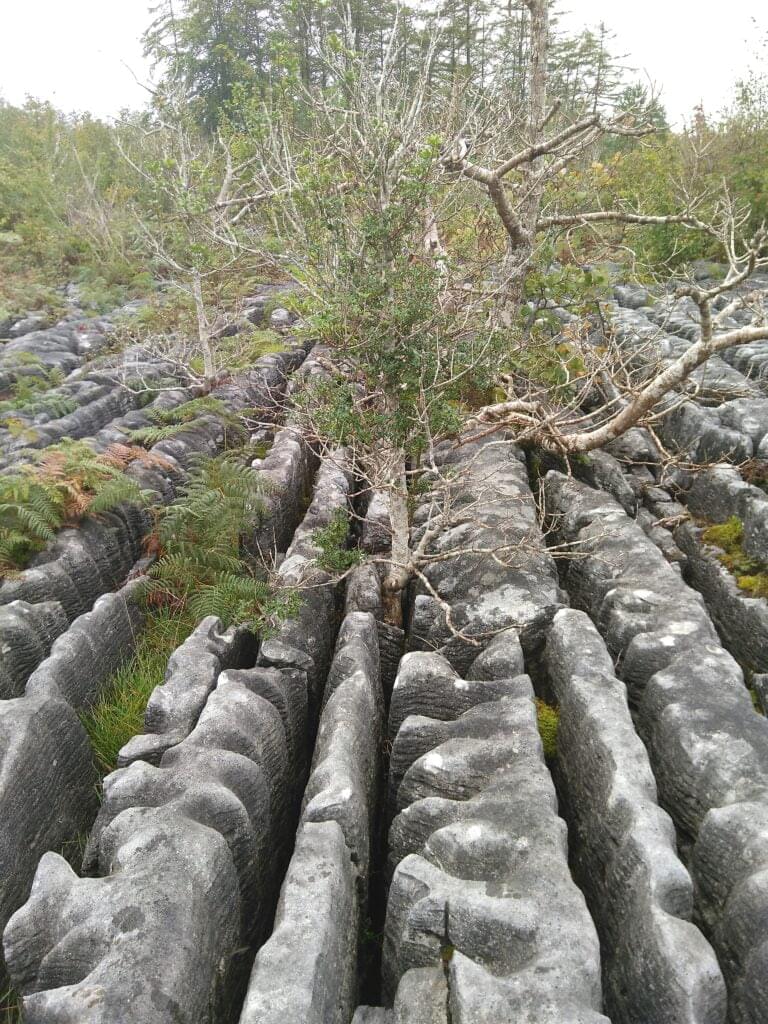
As mentioned before, there is still a remarkable area of the geopark region where the sediment cover is thin or non-existent over the limestone. This not only allow us to see the karst landscape in full view, but it also creates special habitats for plants and animals in the various cracks of the bedrock. The cracks in the bedrock on limestone pavement are called grikes and the flat area in between them are the clints. While clints are way too exposed to support much life, the grikes offer a warm and sheltered refuge for plants. As in the Burren, this has led to its colonisation by rather rare species not found in other habitats in Ireland.
MARL LAKE
Lough Carra is one of the few rare examples of marl lakes in western Europe. Marl is a deposit of calcium carbonate that accumulates on the lakebed due to the action of cyanobacteria. The catchment of Lough Carra, the area from where the water flowing into it comes from, is entirely lying over Carboniferous limestone. This has the effect of saturating its waters with dissolved calcium carbonate which is then used by the bacteria. It can be compared with the accumulation of dental plaque or tartar on human teeth with the calcium phosphate contained in saliva.
The marl in a low-nutrient lake (also called oligotrophic) is white and the waters are clear. Due to the shallow basin of Lough Carra, this has led to its white lakebed being visible in most parts. Indeed, it was originally called Fionn Loch Ceara or the “white lake of Ceara” because of this. The colour of the lakebed affects the light over the lake surface which has inspired artists over the ages. The low-nutrient waters have also led to the lake being a refuge for a number of aquatic species like the Mayfly. The recent increase of nutrient input in the lake has changed its status to mesotrophic and is posing a threat to both the quality of the water and the wildlife of the lake and surrounding areas.
