跳过链接

了解

Resources

Learning in the landscape

As part of our June 2021 conference, our two geopark geologists, Amrine Dubois Gafar and Benjamin Thébaudeau, discussed ideas about outdoor education with two local primary school teachers Michelle Granahan and Charlotte Duignan. A large part of this project is to promote the landscape as an outdoor classroom. During the video, ideas on how to use the landscape in the classroom are discussed, and 3 sites are suggested as examples where such school trips could take place.

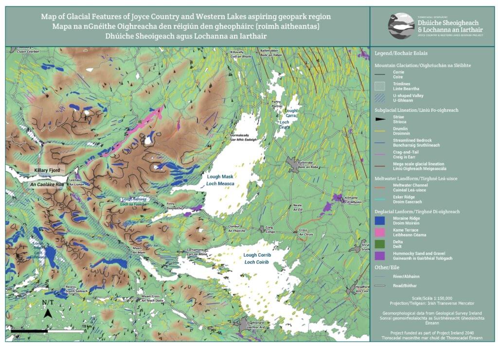
Maps

Use our geological and glacial features maps in the classroom. Curious as to what rocks lay beneath your feet? Ever wondered if that hill is made from sediments left over from the Ice age? Use both maps to explore questions such as these in a hands-on approach in your classrooms. The maps are also good for learning cardinal directions and seeing which other natural features can be seen in the Joyce Country & Western Lakes geopark region.

Some printed copies are available on request. Click on the images to open up the pdf.

Place Name and Geology booklet

This booklet was developed by JCWL GeoEnterprise and funded by Geological Survey Ireland. This bilingual English/Irish booklet follows and adds to the expert works of the late Fiachra McGowan and the late Tim Robinson by focussing on the geological and geomorphological features recorded in place names in Ireland with more specific examples from the region.

Our region has fascinating examples of such links like in Cloghbrack (an Chloch Bhreac – the speckled rock) or Aill Dubh (Black Cliff) which directly link with the colour of their local bedrock. Places like Ballintubber (Baile an Tobar – the townland of the well) tell us about our karst landscape in limestone and others like Clogher (an Clochar – the rocky place) remind us of the ice-sheets that left stones in our soil. The booklet also provides tools to research your local geology all over Ireland with a glossary of frequent terms used.

You can download the pdf of the booklet in either the Irish or English version. Some printed copies are available on request. Click on the image to open up the pdf.

Animated videos

These animated videos, created thanks to funding from Geological Survey Ireland and produced by Noho Dublin (for the first two) and Aperture Media (for the karst one), were written by the geologists of the geopark. They aim to illustrate the geological processes that were behind the formation of our region’s landscape and are available in both English and Irish.

Geoschol

The Geoschol initiative was developed to introduce geology in a very accessible way. Check out the website to download activity sheets and to get ideas on how you can teach geology in your classroom.

Maps

Use our geological and glacial features maps in the classroom. Curious as to what rocks lay beneath your feet? Ever wondered if that hill is made from sediments left over from the Ice age? Use both maps to explore questions such as these in a hands-on approach in your classrooms. The maps are also good for learning cardinal directions and seeing which other natural features can be seen in the Joyce Country & Western Lakes geopark region.

Some printed copies are available on request. Click on the images to open up the pdf.

Place Name and Geology booklet

This booklet was developed by JCWL GeoEnterprise and funded by Geological Survey Ireland. This bilingual English/Irish booklet follows and adds to the expert works of the late Fiachra McGowan and the late Tim Robinson by focussing on the geological and geomorphological features recorded in place names in Ireland with more specific examples from the region.

Our region has fascinating examples of such links like in Cloghbrack (an Chloch Bhreac – the speckled rock) or Aill Dubh (Black Cliff) which directly link with the colour of their local bedrock. Places like Ballintubber (Baile an Tobar – the townland of the well) tell us about our karst landscape in limestone and others like Clogher (an Clochar – the rocky place) remind us of the ice-sheets that left stones in our soil. The booklet also provides tools to research your local geology all over Ireland with a glossary of frequent terms used.

You can download the pdf of the booklet in either the Irish or English version. Some printed copies are available on request. Click on the image to open up the pdf.
Animated videos

These animated videos, created thanks to funding from Geological Survey Ireland and produced by Noho Dublin (for the first two) and Aperture Media (for the karst one), were written by the geologists of the geopark. They aim to illustrate the geological processes that were behind the formation of our region’s landscape and are available in both English and Irish.

Maps

Use our geological and glacial features maps in the classroom. Curious as to what rocks lay beneath your feet? Ever wondered if that hill is made from sediments left over from the Ice age? Use both maps to explore questions such as these in a hands-on approach in your classrooms. The maps are also good for learning cardinal directions and seeing which other natural features can be seen in the Joyce Country & Western Lakes geopark region.

Some printed copies are available on request. Click on the images to open up the pdf.

Place Name and Geology booklet

This booklet was developed by JCWL GeoEnterprise and funded by Geological Survey Ireland. This bilingual English/Irish booklet follows and adds to the expert works of the late Fiachra McGowan and the late Tim Robinson by focussing on the geological and geomorphological features recorded in place names in Ireland with more specific examples from the region.

Our region has fascinating examples of such links like in Cloghbrack (an Chloch Bhreac – the speckled rock) or Aill Dubh (Black Cliff) which directly link with the colour of their local bedrock. Places like Ballintubber (Baile an Tobar – the townland of the well) tell us about our karst landscape in limestone and others like Clogher (an Clochar – the rocky place) remind us of the ice-sheets that left stones in our soil. The booklet also provides tools to research your local geology all over Ireland with a glossary of frequent terms used.

You can download the pdf of the booklet in either the Irish or English version. Some printed copies are available on request. Click on the image to open up the pdf.
Animated videos

These animated videos, created thanks to funding from Geological Survey Ireland and produced by Noho Dublin (for the first two) and Aperture Media (for the karst one), were written by the geologists of the geopark. They aim to illustrate the geological processes that were behind the formation of our region’s landscape and are available in both English and Irish.

Maps

Use our geological and glacial features maps in the classroom. Curious as to what rocks lay beneath your feet? Ever wondered if that hill is made from sediments left over from the Ice age? Use both maps to explore questions such as these in a hands-on approach in your classrooms. The maps are also good for learning cardinal directions and seeing which other natural features can be seen in the Joyce Country & Western Lakes geopark region.

Some printed copies are available on request. Click on the images to open up the pdf.

Place Name and Geology booklet

This booklet was developed by JCWL GeoEnterprise and funded by Geological Survey Ireland. This bilingual English/Irish booklet follows and adds to the expert works of the late Fiachra McGowan and the late Tim Robinson by focussing on the geological and geomorphological features recorded in place names in Ireland with more specific examples from the region.

Our region has fascinating examples of such links like in Cloghbrack (an Chloch Bhreac – the speckled rock) or Aill Dubh (Black Cliff) which directly link with the colour of their local bedrock. Places like Ballintubber (Baile an Tobar – the townland of the well) tell us about our karst landscape in limestone and others like Clogher (an Clochar – the rocky place) remind us of the ice-sheets that left stones in our soil. The booklet also provides tools to research your local geology all over Ireland with a glossary of frequent terms used.

You can download the pdf of the booklet in either the Irish or English version. Some printed copies are available on request. Click on the image to open up the pdf.
Animated videos

These animated videos, created thanks to funding from Geological Survey Ireland and produced by Noho Dublin (for the first two) and Aperture Media (for the karst one), were written by the geologists of the geopark. They aim to illustrate the geological processes that were behind the formation of our region’s landscape and are available in both English and Irish.

Maps

Use our geological and glacial features maps in the classroom. Curious as to what rocks lay beneath your feet? Ever wondered if that hill is made from sediments left over from the Ice age? Use both maps to explore questions such as these in a hands-on approach in your classrooms. The maps are also good for learning cardinal directions and seeing which other natural features can be seen in the Joyce Country & Western Lakes geopark region.

Some printed copies are available on request. Click on the images to open up the pdf.

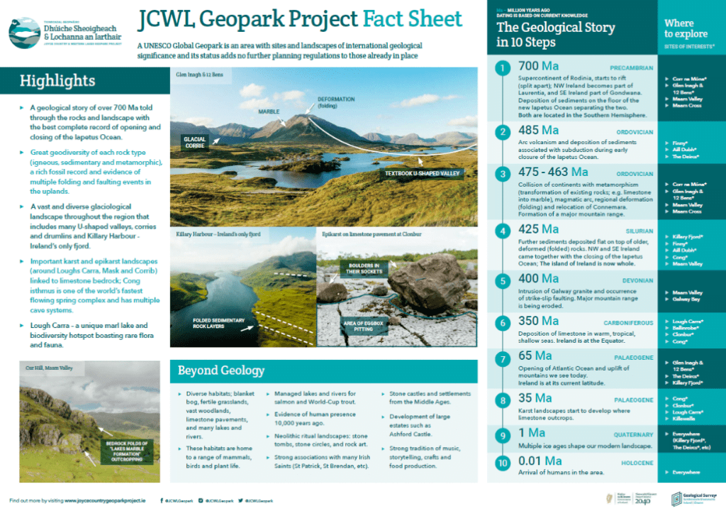
Fact sheet

To complement the Geopark Ambassador Course, a fact sheet has been designed. This fact sheet summarises the main points of the geological story, and the geological and wider highlights of our geopark project region.

Click on the image to download the pdf version of the fact sheet.

Animated videos

These animated videos, created thanks to funding from Geological Survey Ireland and produced by Noho Dublin (for the first two) and Aperture Media (for the karst one), were written by the geologists of the geopark. They aim to illustrate the geological processes that were behind the formation of our region’s landscape. They help to tie in elements covered in the Geopark Ambassador Course and are available in both English and Irish.

Back to learning homepage
ZH