PEOPLE
The landscape of Connemara and south Mayo is rugged, and the Atlantic weather front has been a staple of the way of life in the region for millennia. The arrival of the first settlers in Ireland stretches back to 12,000 years ago, after the end of the Ice Age. These people lived according to the Mesolithic (or Middle Stone Age)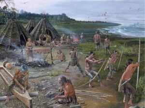 culture and were nomadic, mainly foraging the shores of seas, lakes and rivers. There is no evidence of these people settling in our region but stone tools called Bann flakes from that era were found on the shores of Lough Corrib just outside Oughterard. and at other sites in the wider region. These artefacts indicate the presence of a local population at the time.
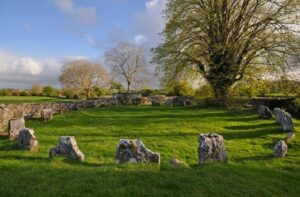
Current thoughts point to a second wave of settlers coming from mainland  Europe bringing agriculture to Ireland about 6,000 years ago at a time called the Neolithic (or New Stone Age). The earliest farmers brought with them crops such as wheat and barley, animals such as cattle, horses and sheep and a more settled way of life. They have left their marks in Ireland from their monumental constructions such as Megalithic tombs, standing stones and stone circles like those at Nymphsfield (to the north east of Cong), which attest to their seasonal rituals linked to the sun and moon. Some of their graphic art is also inscribed in stone in the very rare rock art found on slabs of sandstone outcropping in the Partry mountains.
 Neolithic people have also left a number of log boats remain at the bottom of Lough Corrib that were identified recently thanks to a substantial bathymetric survey of the lake. These canoe-type of boats are made of a single piece of wood that is carved out. Only a number of them were dated with radiocarbon and a significant contingent comes from the Neolithic making it one of the richest area in Europe for such finds.
We are not sure whether further invasions or whether natural/transient changes in the culture of the people that lived in Ireland led to a new development in material culture around 2,500 years ago, with the mastery of metal tools and weapons, first in bronze and then in iron.
Monuments from the Bronze Age include the tombs called barrows, which are low earthen hillock of which only a few examples exist in our region. A hillfort at Finny and two promontory forts in Lough Carra (although these haven’t been specifically dated) are associated with this period as are a number of burnt mound called fulachta fiadh. We also found the remain of two timber causeways built to cross Lough Carra that would have shortened travel by about 14km. The oldest one is 100m long and has been dated at about 1,570BC whilst the longest one between Kilkeeran and Ballycally is 700m long and has been dated at about 1,100BC.
The Iron Age is also associated with the rise of the Irish language and the Celtic art forms, however only a handful of archaeological sites were found from that era in Ireland. An interesting feature from that era is the original tóchar or “chariot-road” linking the Connacht royal site of Rathcroaghan to Croagh Patrick via Ballintubber, probably because of the natural spring there. Annals records its construction to 350AD with oak beams overlaid by flagstones.
Christianity famously came to Ireland about 1,500 years ago and the early Christians established many churches and monasteries throughout the country such as the ones associated with Saint Patrick in county Mayo, especially from Ballintubber to Croagh Patrick. Saint Patrick is also associated with Mám Éan (the pass of the birds) in the Maumturks marking the border between Joyce Country and Connemara and where a pilgrimage is still ongoing, and with the foundations of the first church on the island of Inchagoill on Lough Corrib, where one can find one of the earliest examples of the Irish language written in Latin script (dated to the 6th century AD). Other famous saints either originated from the area or founded churches here; Saint Brendan the navigator reputedly founded a church on Inchiquin and at Rosshill Cemetery in Clonbur, Saint Fursa is recorded to have founded the first church at Killursa before he went on missionary missions to East Anglia and in Merovingian France, and Saint Feichin is said to have established the abbey at Cúnga Fheichín (the old name of Cong).
Since these times and over the years, a number of natural springs across the country have been used for catholic rituals and associated with saints to become holy wells. This is of particular importance in the karstic landscape to the east of our region where the springs are more common. The area around Ballintubber Abbey has three natural springs that are holy wells including the famous Tobar Phádraig (or holy well of Saint Patrick) that feeds a stream flowing into Lough Carra.
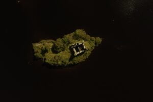
The early medieval period saw the development of excellent craftmanship in Ireland and great examples of their creations are the numerous illustrated bibles such as the world-famous Book of Kells. Settlements from these times left considerable evidence in the landscape with crannogs (artificial island dwellings in lakes) and ringforts (circular earthen and stone banks) which were the settlements of the Irish land owners and have been considered as fairy forts after their abandonment.
 The Anglo-Norman invasion from 1169 AD introduced numerous changes to monumental architecture in Ireland, including the establishment of borough towns (such as Ballinrobe and Burriscarra) and the development of Motte structures followed by stone keeps and castles. The conquest of Connacht by the Anglo-Normans under Richard de Burgh was only achieved in 1232 and saw the development many castles on the shores of Lough Carra (Castle Carra, Castleburke), Lough Mask (Ballynonagh, Ballykine) and Lough Corrib (Castlekirk, Ashford Castle, Annaghkeen castle).
Jus t prior to the conquest, a number of new religious orders arrived in Ireland and the Augustinian Order was particularly important for the region. The then Gaelic lords of Connacht, the O’Connors, promoted a number of large abbey foundations that showcased the best architectural achievement of the time (a style called the “School of the West”); examples of these are Ballintubber Abbey, Inishmaine Abbey, Ballinrobe
 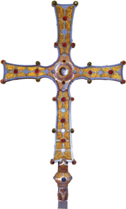 Abbey or Cong Abbey, where the last High King of Ireland, Rory O’Connor, lived out the end of his life and was buried. The ornamental Cross of Cong is a testament to the high technical prowess of the medieval craftsmen of the area. Other religious orders also built settlements in the area like the Carmelites at Burriscarra Abbey or the Franciscans at Ross-Errily Abbey beside Headford.
To note, the Joyce Clan, another Anglo-Norman family, arrived to the area in the 13th century as well and gave their name to a number of valleys in the Barony of Ross from which we get the name for Joyce Country.
After centuries of semi autonomy from the Crown of England, the change in attitudes towards Ireland from the Tudor monarchs, in particular the repossession of church lands and the disbandment of Catholic religious orders, led to the direct rebellion of a number of Gaelic lords, famously the O’Neills and O’Donnells of Ulster. In parallel to this conflict at the end of the 16th century, the three most powerful clans of the west Connacht area were fighting for land; namely the MacWilliam Burkes (descendants of the De Burghs and by then fully gaelicised), the O’Flathertys in Connemara and the O’Malleys in Clew Bay and all down the west coast. Grace O’Malley (Gráinne Mhaol Ní Mhaille) was invested in this conflict, being the chieftain of the O’Malleys and having been married twice; once to a O’Flatherty and once to a Burke. She famously fought to keep her first husband’s castle at Castlekirk with success. The English Crown, through their agent Richard Bingham, managed to exploit these divisions to diminish the local power which ultimately led to the destruction of the old Gaelic way of life. This was exacerbated with planned colonisation in the second half of the 17th century, following Oliver Cromwell’s invasion of Ireland. This time also saw the development of penal laws which aimed to restrict Catholics of their freedom to practice their religion and to force a conversion to the reformed Church of England.
At this time, power resided in the hands of a few English landlords who owned large estates. These were mainly protestant families, like the Brownes at Ashford Castle, though the Moores of Lough Carra were the notable exception. Most landlords managed their land remotely through agents collecting rents and “improving” the financial return on the use of the land. The upland landscape changed dramatically then, with the removal of prior practices of “booleying”, a local term for the summer pasture of cattle in the uplands, and the massive expansion of sheep grazing. This time also saw the extinction of wolves in Ireland due to direct payments organised by the authorities for each wolf killed in the land. This century ended with an armed rising for independence in 1798 which culminated in the arrival in Co Mayo of a contingent of French republican soldiers but was ultimately thwarted.
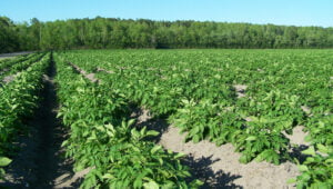 Traditionally, people earned their living from subsistence farming and to some extent, fishing. Potato cultivation brought with it great nutritional opportunities and population growth, but also tremendous famine and human tragedy in the 1840s with starvation, destitution, death and migration. Mayo and Galway were especially badly affected leaving behind abandoned fields and villages. Relief projects, like the Cong Canal, were organised by the landed gentry to offer employment for the destitute and poorhouses were built like the one in Ballinrobe.
The main roads of Joyce Country and Connemara did not exist at the start of the 19th century. Following the foiled rising of 1798, the local landlords and authorities started to map the country systematically and in detail and was the first survey of its kind worldwide. Quite large areas of Connemara and Joyce Country were still very hard to access and so engineers were drafted with surveying the land for resources and planning out new communication routes. An important person for the history of this area is the Scottish engineer Alexander Nimmo, who is responsible for early tracing of most of these roads. He famously resided in the now called Keanes Hotel in Maam village. The original survey was followed by a geological survey (Geological Survey Ireland was founded in 1845) which aimed to uncover any untapped mineral resources in the land. The earliest geological map of the area was produced in the 1860s by a group of field mappers under George Kinahan. The mapping proved fruitful with the development of an intense, but short-lived, mining industry in Joyce Country for silver and lead. Famous examples are Glengowla and Clements Mine. Further developments in the area were the opening of railroads, including the one linking Galway city to Clifden through Oughterard, Maam Cross and Recess.
The century also saw the development of the Land League, an organisation founded in Castlebar, Co Mayo for the rights of Irish tenants to a fair rent and the possibility to own their land. It organised many popular actions against the eviction of poor tenants and the “boycott” of the payment of rent to landlords. In fact, the term “boycott” was coined at this time in the village of The Neale as international journalists were covering the political action of the local people of Ballinrobe against the agent Charles Boycott who was working for the local landlord. The organisation was successful and allowed for the idea of Independence to grow stronger.
The Easter Rising in 1916 was the spark that started the process towards Irish Independence. During the War of Independence that followed, small groups of IRA soldiers organised in flying columns were active in the area. Particular events of importance were the Tourmakeady ambush of May 1921 and the hiding of the Connemara flying column from Rosmuc in the Maam valley in that same year. The Irish Free State was finally declared in 1922 thanks to a treaty signed between the Irish and British governments; the Irish Civil War that ensued opposed proponents and opponents to the treaty. Some of the opponents set fire to a number of landed gentry manor houses, like Moore Hall which was destroyed in 1923.
The use of the Irish Language has declined steadily since the 18th century and the Great Famine accelerated this change. Areas where Irish was still spoken by a large proportion of the population were recognised officially as the Gaeltacht in 1926 and a commission of the now Irish Republic was tasked to map its extent in the 1950s. It includes a large extent of Joyce Country, which was where the first college for the training of Irish language teacher was opened by the Gaelic League at the turn of the century in Tourmakeady.
In the most recent generations, there has been a move towards the development of manufacturing, services and tertiary industries; in particular tourism. The attraction of angling on the large lakes has seen significant recognition since the 1960s, following earlier such developments in the lakes of Connemara for the landed gentry in the previous century.
The wider region is served by Galway City, and the larger towns of Clifden in Connemara and Castlebar and Westport in Co. Mayo. An excellent provision of secondary and tertiary education provides a well-educated population. Crafts indigenous to this part of Ireland are still practiced and preserved, as are local styles of dancing, music, and sports.
More information at : https://heritage.galwaycommunityheritage.org/content/category/places/joyce-country-places
As well as from the books and articles listed here.