Skip links

Our Heritage

A SUMMARY

EXPLORE OUR WHISPERING LANDSCAPE

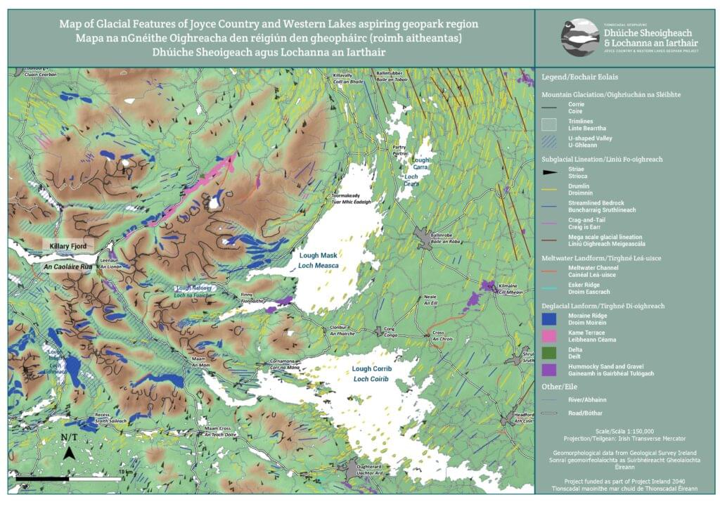
Visiting our ancient landscape is no mean feat as it will allow you to explore unique testimonies of geological processes that took place over the last 700 million years (see below). Our region can boast to have the best complete record of the Grampian-Taconic orogeny, a geological event that started about 500 million years ago involving landmasses that are now found in the Appalachians (North America, find out more on the Cabox aspiring geopark website), Greenland, north west Ireland and Scotland(find out more on the North West Highland UNESCO Global Geopark website), with evidence of opening and closing of the Iapetus Ocean . This event saw the development of volcanic and magmatic arc, metamorphism (including the formation of green Connemara Marble) and regional scale deformation linked with the creation of a significant mountain range. Thanks to these various processes, the region displays a great geodiversity with outcrops of a wide range of rocks from each main type (igneous, sedimentary and metamorphic), a rich fossil record for the Ordovician, Silurian and Carboniferous geological periods and evidence of multiple folding and faulting events in the uplands. Ireland’s only fjord sits at Killary Harbour on the Wild Atlantic Way amidst a vast and diverse glaciological landscape throughout the region both in our mountains and our plains around our great lakes. With limestone outcropping in the eastern half of our area, major karst and epikarst landscapes were developed, with a specific expression in the Cong isthmus where you can find one of the world’s fastest flowing spring complex and multiple cave systems. Modern geological and biological processes are still at play today and a great place to experience these is at our unique marl lake and biodiversity hotspot, Lough Carra.

Read more on the geology here.

A STORY 700 MILLION YEARS IN THE MAKING

Dating in Ma (million years ago) is based on current knowledge

  • 700 Ma Supercontinent of Rodinia starts to rift (split apart); NW Ireland becomes part of Laurentia, and SE Ireland part of Gondwana. Deposition of sediments on the floor of the new Iapetus Ocean separating the two. Both are located in the Southern Hemisphere; explore at Corr na Móna and Glen Inagh and 12 Bens.
  • 485 Ma Arc volcanism and deposition of sediments associated with subduction during early closure of the Iapetus Ocean; explore at Finny, Aill Dubh and The Deircs.
  • 475-463 Ma Collision of continents with metamorphism (transformation of existing rocks; e.g. limestone into marble), magmatic arc, regional deformation (folding) and relocation of Connemara. Formation of a major mountain range; explore at Corr na Móna and Glen Inagh and 12 Bens.
  • 420 Ma Further sediments deposited flat on top of older, deformed (folded) rocks. NW and SE Ireland came together with the closing of the Iapetus Ocean. The island of Ireland is now whole; explore at Finny and Cong.
  • 400 Ma Intrusion of Galway granite and occurrence of strike-slip faulting. Major mountain range is being eroded; explore at Galway Bay (south of Maam Cross) and in the Maam valley.
  • 350 Ma Deposition of limestone in warm, tropical, shallow seas. Ireland is at the Equator; explore at Moore hall and Lough Carra, Ballinrobe, Cong and Clonbur.
  • 65 Ma Opening of Atlantic Ocean and uplift of mountains we see today. Ireland is at its current latitude; explore at Glen Inagh and 12Bens, Killary fjord, Aill Dubh, Finny, Clonbur, Corr na Móna and The Deircs.
  • 35 Ma Karst landscape start to develop where limestone outcrops; explore at Moore hall and Lough Carra, Ballinrobe, Cong and Clonbur.
  • 1 Ma Multiple ice ages shape our modern landscape; explore everywhere in the region but especially at Killary fjord, Aill Dubh, Finny, Clonbur and Glen Inagh and 12 Bens.
  • 0.01 Ma Settlements of humans in the area; explore everywhere in the region.

A RICH ENVIRONMENT

A rich and diverse geological landscape leads to a great diversity of habitats since bedrock geology influences soil type, slopes, drainage and groundwater. Our region showcases blanket bog in the uplands, more fertile grasslands in the lowlands over limestone bedrock, vast conifer and semi-native woodlands, limestone pavements and many lakes and rivers. In turn, a wide range of mammals, birds and plant life make a home of these habitats. Some of these habitats have national legal protection for the types of species that inhabit them, such as aquatic birds (gulls, swans, terns) nesting in the great lakes, the lesser horseshoe bat in its northernmost European habitat and many others. The lakes and rivers are also managed for angling wild salmon and trout (the world-cup trout fly-fishing competition has occured annually in Ballinrobe since the 1950s). The land is also managed following traditional farming practices that allows for the rearing and harvesting of high-quality food products.

Read more on our range of habitats here.

THE PEOPLE AND THE LAND

We have evidence of humans settling on our lake shores as early as 10,000 years ago during the Mesolithic but they really started to make their marks on the landscape when agriculture was introduced 4,000 years later with stone tombs and ritual landscapes (stone circles and rock art). The region continued to have a strong spiritual importance with clear historical associations to the early Christian church in Ireland and in particular St Patrick, St Brendan (the navigator) and St Fursa. Later on in the Middle Ages, the eastern shores of the lakes were a stronghold of resistance to Anglo-Norman invasion and were strongly developed with the lakes becoming a frontier zone with many castles erected around them. The landscape changed more radically in the 17th and 18th century as the mountains were cleared of cattle and wildlife and our modern farming practices were adopted leading to the development of an environment we would recognise today. The region was then significantly made more accessible with the construction of new roads, railways, quays and mines. The tragedy of the Great Potato Famine was especially felt in the area with entire villages abandoned, of which only ruins remain today. Famous events of the Irish War of Independence happened here and the particular language and culture of the western part of our region led to the creation of the formal administrative Gaeltacht in the new Irish State in the mid-20th century. The JCWL region stands today with a strong tradition of music, storytelling, crafts and food production through the medium of the Irish language for all to learn from, share and enjoy.

Read more on our archaelogy and history here.

EN